
Local Trails & Maps
We’re the Mountain Bike Capital of Georgia!
Pedal some of the Southeast’s most gorgeous—and rowdy—mountain bike trails. With 100+ miles of singletrack, Gilmer County is officially the “Mountain Bike Capital of Georgia,” serving up everything from mellow cross‑country to technical downhills and the state’s oldest MTB trail, the classic River Loop along the Cartecay River.
Ellijay also dishes out unreal gravel and road riding, with long, scenic miles and hardly any cars in sight. These trails and routes are our backyard playground, and we’ve got maps and plenty of real‑world stories—swing by the shop and we’ll point you to your next favorite ride.
Talking Rock Nature Preserve
Skill Level: Beginner & Intermediate. The Talking Rock Nature Preserve includes 220 acres of natural beauty that provide opportunities for environmental education and a diverse mix of recreational opportunities open to the public. TRNP is just south of Ellijay and only a short trip from downtown. Jon’s Loop is perfect for new riders or kids getting started in mountain biking. Additional trails have some climbing, technical sections, and fun downhills.
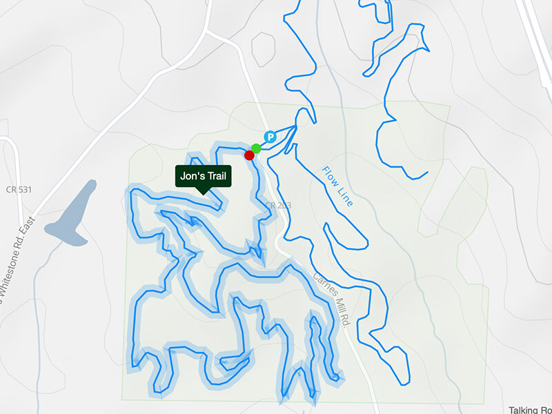
Talking Rock Nature Preserve - Paper Map
Ridgeway Mountain Bike Trails
Skill Level: Beginner, Intermediate & Advanced. You will find a variety of trails for all skill levels at Ridgeway. Develop your descending skills on Smooth Operator. This super fun flow trail loop has plenty of whoop-tee-do's, berms, and a nice smooth climb back to the top to ride it again. If it’s technical terrain you crave, then hit the Black Diamond trails. There is a Single Black (Ledges) and a Double Black (Roots & Chutes), giving you the perfect opportunity to take your skills to the next level. These trails are located at the Ridgeway Recreation Area on Carters Lake.

Ridgeway Mountain Bike Trails - Paper Map
Amadahy Trail
Skill Level: Beginner & Intermediate. The rolling 3.7 mile Amadahy loop follows the gentle contour of a peninsula on Carters Lake. Take in the lake views on nearly the entire trail. Amadahy is a blast in both directions. This one is a favorite for families and kids.

Amadahy Trail - Paper Map
The Pinhoti - Cohutta Sections 1, 2 & 3
Epic. The Pinhoti Trail crosses the Blue Ridge fault line south of Chatsworth. East of that you will find the big mountain climbs of the Cohutta. Head west for the Ridge and Valley sections, with numerous ridge climbs and long stretches of ridge-top riding. There's an 8-mile loop in the Pocket area between Horn and John’s Mountain; on the east side, the MTB community recognizes 4 major loop rides between Fort Mountain and Bear Creek. In short, the Pinhoti is a unique, long and extremely varied trail that could keep any mountain biker entertained indefinitely.
Ride them separately, or combine for a long, super epic ride! All the Pinhoti trails are rideable in either direction. P1, P2 & P3 are also easily connected with Bear Creek (sometimes called Bearhoti). Skill Level for P1, P2 & P3: Intermediate & Above.
Pinhoti 1, 2 & 3 - Paper Map
Mega Map - Paper Map
Pinhoti 1
Skill Level: Intermediate. P1 is a 4 mile ride with a 1,205 ft climb and then a -1,232 ft descent! We usually ride from the Bear Creek side, but it can also be ridden by starting on gravel from Wilderness Road. Whichever you choose, it’s a fun ride with occasionally breaks in the trees to see the ridges.

Pinhoti 2
Skill Level: Intermediate. P2 can be ridden a multitude of ways and we love them all. We typically start by parking on Gates Chapel and riding a short stretch of gravel on Wilderness Road to the trailhead. P2 packs in a lot of downhill with minimal climbing. For the 7 mile loop - take a left on Conasauga Road at the end of P2, then a left on Shakerag Road to ride back to Gates Chapel. For more trail, take a right at the end of P2 and ride up Conasauga Road slightly, then jump onto P3 on the left. For more gravel, keep on going and you’ll see Mulberry Gap and can take the longer gravel loop back on Old CCC Camp Road.

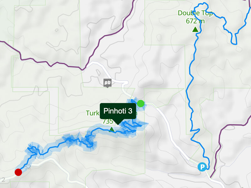
Pinhoti 3
Skill Level: Intermediate. P3 is a 4.7 mile trail that climbs 1,300+ feet to the overlook on Hwy 52 and includes scenic ridge riding and some tight switchbacks to test your skills. Pass through a wide variety of North Georgia flora and fauna that changes with every season. You’ll be rewarded with plenty of downhill on the return ride.
Bear Creek
Skill Level: Intermediate. Hands down, everyone’s favorite! Bear Creek has technical single track, a multitude of stream crossings, the giant Gennett Poplar tree (400 years old), and a spectacular long-range view from the overlook. The out-and-back route is 6 miles uphill (not too steep) to the overlook, and then it’s a killer 6 mile descent back to the car! Be sure to keep an eye out for hikers. There are multiple ways to ride Bear Creek including a loop, a figure 8, or a gravel ride to the top. Check with us if you have questions.
Parking Tip: From the shop, take Hwy 52 west to mile marker 8 (on left side of the road); turn right onto Gates Chapel; go 5.4 miles to small bridge; park on the side of the road. (Please do not use the side of the road as an outhouse or changing facility! Our local neighbors don’t appreciate the sights!)

Mountaintown
Skill Level: Advanced. The Mountaintown trail is one of North Georgia’s hidden backcountry gems with varied terrain including LOTS of technical downhill, large creek crossings, and rock gardens. If you don’t feel like riding the 14 mile gravel ride to the top, you can snag a shuttle ride with Mulberry Gap.

Windy Gap
Skill Level: Advanced. If you like your downhills long and jumpy, you’re going to like Windy Gap. Be sure to have your brakes checked beforehand. Some people ride up to the start of this one, but most shuttle.

Mountaintown & Windy Gap - Paper Map
River Loop
River Loop – Skill Level: Intermediate with Advanced Downhill Section. Officially, the oldest mountain bike trail in Georgia, this 3.75 mile loop may be short, but it’s punchy! The River Loop is a single track trail with some double track at the beginning and end. A technical downhill descends to the Cartecay River. If you do not have the skill level to ride the downhill section, be sure to dismount and walk this part. There are plenty of shady spots along the river to pull over and enjoy the view, if you feel so inclined. Some sections of the trail are lined on both sides with ferns. You’ll definitely get your workout on the steep climb back out.
Red & White – Skill Level: Beginner & Intermediate. You can also hop onto the Red & White trail near the end of the River Loop to add on an extra 2 miles.

River Loop - Paper Map
Fort Mountain State Park
Take Hwy 52 west out of Ellijay approximately 12 miles to the top of Fort Mountain; the park entrance is on the right. Pay a $2 parking fee at the Park Office and ask for a trail map. This is the site we host our legendary Drama Queen race, for a reason!
East-West Loop – 14 miles, Skill Level: Advanced. Heads up - this is a very challenging trail. The main highlights are a STEEP powerline downhill that drops off the side of the mountain, and a LONG technical climb that starts at mile 11. There is some spectacular scenery and super-fast rolling sections. Bring plenty of water and extra food. There is no shortcut out. Our friends from Florida HATE this trail.
Cool Springs Loop – 7 miles, Skill Level: Advanced. This trail starts out as the same trail as the East-West loop then turns left and goes downhill around eleven switchbacks to the base of the mountain. Some great scenery, a boulder field and then the same LONG climb back to the parking lot.
Gold Mine Loop – 6 miles, Skill Level: Intermediate. This trail is almost entirely doubletrack with some technical sections, some scenic viewing areas, good curves and plenty of speed. There is a somewhat steep, short rocky climb back to the parking lot, but all in all, a fun trail.
Lake Loop – 2 miles, Skill Level: Beginner. This little loop is fun for smaller kids or a true beginner as it’s relatively flat, but still woodsy. Enjoy pretty lake scenery, a few roots, and a couple of rocks for practice. The whole trail is covered in mulch to make it soft.

Fort Mountain Trails - Paper Map
Jake Mountain / Bull Mountain
Skill Level: Intermediate & Advanced. The Jake/Bull trail system offers almost 40 miles of trails and is home to the Fools Gold 50 and Fools Gold 100 annual bike races. This trail system is shared by horses and hikers. The Jake Mountain Trail System and Bull Mountain Trail System connect to form a complex system of scenic trails within a four square mile area of the Chattahoochee National Forest's Blue Ridge Ranger District. Located in western Lumpkin County, Jake/Bull is located less than ten minutes from downtown Dahlonega. The system is made up of interconnecting dirt trails and gravel roads which are accessed by two trailheads.

Jake / Bull Mountain - Paper Map
Stanley Gap
Skill Level: Advanced. We like to ride this trail from the Stanley Gap (not Aska Road) side and add Flat Creek for some additional miles. This trail has steep ridge lines, narrow tree openings, spectacular scenery, narrow, off-camber technical downhills, and did we mention extremely difficult climbing?
Directions to trail: Take Hwy 515 north from Ellijay to Rock Creek Road; turn right and follow road approximately 3 miles (past the game check station) to the Stanley Gap parking lot.

Stanley Gap / Aska Trail System - Paper Map
Gravel & Bikepacking Routes
Our friends at Mulberry Gap have compiled some awesome gravel and bikepacking routes. The Mulberry Crew will take exceptionally good care of you if you stop in for a stay. We highly recommend their phenomenal food and beer selection!


Road Rides
If you prefer to stick to the road, no worries! We have beautiful scenery, long-range views, and plenty of steep climbing to keep you entertained. Here are a few favorites from our road riding friends…
Gianni Bugno - 41 Miles
Marco Pantani - 69 Miles
Giro De Ellijay - 104 Miles
Tour of the Ardennes Loop - 65 Miles
Tour of the Ardennes Secondary Loop - 73 Miles
Medieval Torture Chamber Ride - 96 Miles
Mt. Pleasant Church - Springer Mtn Long Ride - 8.4 Miles
Noontootla Forest Gravel Road Ride - 20.1 Miles
Tour de France Challenge Loop - 77.3 Miles
The Roundtop/Whitestone Road Ride - 40 Miles
The “Real” Burnt Mountain Ride - 50 Miles